|
Rural Incorporated Districts (RID)www.cwposse.org
Set my people free
Coastside group pushing new city
By Tim Hay, STAFF WRITER
Saturday, October 11, 2003 - HALF MOON BAY -- A newly formed Coastside group wants to wrest control of some 30,000 unincorporated acres from an open-space agency and form a new city: the Town of Rural Lands.
The new town would be free from the "tyranny" of County government, environmental groups and the Midpeninsula Regional Open Space District, said Oscar Braun, founder of the Rural Lands Incorporation Now Committee. It would be the first new incorporated area since 1983 when East Palo Alto was formed.
Sustainable San Mateo County Database: LAND USE DATA
| Allocation of Land Uses by County |
| County |
Urban% |
Rural% |
Greenbelt% |
Estimated
UDI1 |
| Alameda |
29.2 |
56.9 |
21.6 |
25 |
| Contra Costa |
30.2 |
46 |
23.8 |
16 |
| Marin |
14 |
35 |
51 |
14 |
| Napa |
4 |
75.8 |
20.2 |
16 |
| San Francisco |
79.4 |
1.3 |
19.3 |
92 |
| San Mateo2 |
26.2 |
39.1 |
34.7 |
22 |
| Santa Clara |
21.5 |
56.9 |
21.6 |
21 |
| Solano |
9.7 |
71.1 |
19.2 |
8 |
| Sonoma |
6.3 |
83.7 |
10 |
18 |
|
Source: Greenbelt Alliance: Greenbelt at Risk 2000
1. Urban Density Index (UDI): Total housing units/urban square miles/100. Source: US Census 2000
2. Total area of San Mateo County is 285,339 acres. |
"We're an agricultural community. We have virtually nothing in common with the urban areas, but our rights are determined by the urban majorities," Braun said Thursday from his home just outside Half Moon Bay. "People (on unincorporated coastal land) want self-governance, self-determination. What we have now is a kind of apartheid system."
Braun, a retired Johnson & Johnson executive, founded the group with former Woodside mayor John Blake, retired civil engineer John Plock and several other Coastsiders.
"This is an attempt by the residents of rural lands to take control of their own destiny," Plock said from his home Thursday.
More than 100 people out of the 6,500 or so that live on rural land have already joined his crusade, Braun said.
On several bellicose Web pages that quote liberally from the Bible and the Constitution -- and feature moving images of wild pigs -- Braun and other committee members denounce "Enviro-cults" and "racketeer-influenced" government, and lay out in detail the plan for the Town of Rural Lands.
The town would be governed by a five-member council, and operate on the property taxes that the open-space agency now receives from Woodside, Atherton, Menlo Park, San Carlos, Redwood City and Portola Valley, Braun said.
City leaders would also collect vehicle-license fees, franchise fees and an assortment of other routine charges. Government services could be kickstarted by an initial general fund balance of $100,000, Braun predicts.
The group must get 25 percent of the 3,200 registered voters of the rural lands to sign a petition in favor of forming the new town, which would be submitted to the County's Local Agencies Formation Commission. The commission has jurisdiction over all boundary changes and annexations on the Peninsula.
If LAFco approved it, the plan could be put before voters in the next general election.
But Martha Poyatos, LAFco's executive officer for the County, does not exactly gush with joy when asked about the prospect.
In a March 27 letter to Braun, she brought up conflicts with the County's General Plan and Local coastal Program, and said a thorough study of the idea could cost the committee more than $100,000.
"Of even greater concern is the fiscal viability of a new city in the current climate of local government finance in which well-established cities with diverse sources of local revenue are being forced to cut vital city programs," Poyatos wrote.
But to Braun, fending off special districts and environmental groups is well worth the risk.
Braun, who formed Save Our Bay and the Half Moon Bay's Surfrider Foundation, has been a thorn in the side of every agency, supervisor or environmental group that has tried -- successfully or not -- to regulate or control unincorporated areas.
"These cults are trying to undermine our communities and our governments," he said.
Braun has fought the Midpeninsula Regional Open Space District since it announced in 1997 a plan to annex some 140,000 acres from Skyline Drive to the coast.
He and others have said the agency has no plan for the area, cannot provide fire safety and has diminished residents' water rights.
In an effort to boost membership in their organization, the proponents of the new town are hosting a forum on Oct. 16 at the 4-Cs ranch off Highway 92 at 7 p.m. It will be moderated by a consultant who works with LAFco in Santa Barbara.
The 4-Cs ranch is owned by John Cozzolino, who tried unsuccessfully to get a permit to bring elephants to his farm for this month's pumpkin festival in Half Moon Bay. County Planners shot down the permit, fanning the anger of Braun and others.
"There's a group of urban officials deciding a farmer can't have something on his land that's permitted by law," Plock said.
IT'S THE "OIL" STUPID !
Question: How many houses in the Rural Lands & how many acres? Answer: SMC Housing Log
Question: How much Open Space Greenbelt in the Bay Area: Answer: Over 1 Million Acres!
Question: What are the San Mateo County Statistics? Here they are!
Click Here for: Map of San Mateo County Unicorporated Area
Sustainable San Mateo County Database: LAND USE DATA
| Allocation of Land Uses by County |
| County |
Urban% |
Rural% |
Greenbelt% |
Estimated
UDI1 |
| Alameda |
29.2 |
56.9 |
21.6 |
25 |
| Contra Costa |
30.2 |
46 |
23.8 |
16 |
| Marin |
14 |
35 |
51 |
14 |
| Napa |
4 |
75.8 |
20.2 |
16 |
| San Francisco |
79.4 |
1.3 |
19.3 |
92 |
| San Mateo2 |
26.2 |
39.1 |
34.7 |
22 |
| Santa Clara |
21.5 |
56.9 |
21.6 |
21 |
| Solano |
9.7 |
71.1 |
19.2 |
8 |
| Sonoma |
6.3 |
83.7 |
10 |
18 |
|
Source: Greenbelt Alliance: Greenbelt at Risk 2000
1. Urban Density Index (UDI): Total housing units/urban square miles/100. Source: US Census 2000
2. Total area of San Mateo County is 285,339 acres. |
SELF GOVERNMENT IS AN AMERICAN TRADITION
When I attended a recent meeting of interested citizens near Half Moon Bay I was impressed by three things:
- The heartfelt concern they have for the future of the coastal side of San Mateo County;
- The fact there was a cross-section of people representing more than 10 separate and identifiable communities;
- The level of knowledge they had regarding local government issues.
The purpose of the meeting, at which I had been invited to speak, was to review governmental options for this area of San Mateo County. Incorporating a city is not like annexing land to obtain services for a proposed development. Matters of government organization reflect the choices communities make regarding the distinct governmental structure desired to carry out civic affairs.
Laws in California are designed to ensure that cities are incorporated only if they are financially feasible and do not adversely affect the finances of the county government. The Local Agency Formation Commission, or LAFCO, is the agency that regulates local government boundaries. It can approve the incorporation of a new city and allow the matter to go to a vote only if it finds the new city is financially feasible and there are no adverse, unmitigated fiscal affects on other agencies as a result. Only then are the voters in the proposed city allowed to decide whether to create a new local government for themselves.
When a community incorporates in California, it does not stop being part of the County. If the coastal area becomes a new city it will remain a part of San Mateo County, as are the 21 existing cities in the County.
However, responsibility for certain types of services would transfer from a board of supervisors that is elected by all the voters in the County to a locally elected city council, the type of local self-representation that is a hallmark of a democratic society.
City obligations in California include local law enforcement, maintenance of public streets and thoroughfares and decisions regarding land use plans, zoning and building regulation. Cities are bound by existing State laws including regulations in the California Coastal Zone.
It is not by accident that State laws require the first action of any new city council to be to adopt all county zoning ordinances and regulations. Any subsequent change in these rules requires public hearings, compliance with environmental rules and conformity with State planning procedures.
Once a city is created those decisions are made by individuals who are elected by and accountable to those within the city boundaries.
The preponderance of San Mateo County voters live on the Bay side of the ridge and most of those within existing cities. As a result decisions regarding local land use and public services for much of the coastal area are made by County officials who do not live in the area and are elected by voters who live elsewhere.
It challenges our sense of democratic institutions when so many decisions about local community issues are made by outsiders who are not directly accountable to those whose lives and property are most affected by the decisions.
Time will tell whether residents of the coastal side of the County have sufficient interest and drive to incorporate a new city that encompasses their lands and varied interests. Should that process proceed and the facts reveal a new city is financially feasible and would not adversely affect the Countys finances, local self-determination is the courses that will clearly recommend itself.
Bob Braitman, Principal
Braitman & Associates
Editors note: Braitman & Associates is a consulting firm providing fiscal analysis and jurisdictional relation services in communities throughout California.
FOR IMMEDIATE RELEASE : September 22, 2003
BRAUNS V. COUNTY OF SAN MATEO
RE: VIOLATION OF CIVIL RIGHTS "42 U.S.C.A. 1983"
October 29, 2003 San Mateo County Times
Open Space District files expansion application
By STAFF REPORTS
Wednesday, October 29, 2003 - The Midpeninsula Regional Open Space District submitted a long-awaited application Tuesday to extend its boundaries to the San Mateo County coast.
The application was received by the San Mateo Local Agency Formation Commission, or LAFCO.
Remember "Loren McQueen v.Mid-Peninsula Regional Open Space District?
Question: Total Parks & Open Space acres in San Mateo County? Answer: Shared Vision 2010
Question: How many houses in the Rural Lands & how many acres? Answer: SMC Housing Log
Question: How much Open Space Greenbelt in the Bay Area: Answer: Over 1 Million Acres!
The program would bring 140,000 acres of open space stretching from Pacifica to the Santa Cruz County line under the jurisdiction of the district.
"The district's Coastside Protection Program is the only way to protect and preserve the coast, while also ensuring accountability to local residents through fair and democratic representation," said Craig Britton, district general manager.
In what district officials call an act of goodwill, their board of directors agreed to eliminate their ability to use eminent domain in the plan's coastal area and to only purchase property from willing sellers.
In addition, the program will only use existing district funds and will not request any additional taxes from area residents, officials said.
County Supervisor Richard Gordon, whose district would be most affected if the application is passed, said he has not yet taken a position on the issue.
John "Jack" Olson, executive manager of the San Mateo County Farm Bureau, said his organization will most likely oppose the plan, but will wait until members can take a closer look at the application.
The ultimate decision on the program will be made by LAFCO.
Why the ``Help RID US" incorporation movement?
Since 1980, the entire Rural Lands communities area have suffered terribly by the unstable, incompetent and corrupt actions of SMC elected officials and planning staff. ``"The official SMC Housing Log 1980-2001 reveal that a total of only ``69" residential occupancy permits have been issued by the County of San Mateo. Why? Because of the Sierra Club and the Committee for Green Foothills undue influenced lobbying on local and state government has STOPPED all community development in the Rural Lands of San Mateo County. The SMC Local Coastal Plan's (LCP) policies of 0% Rural Lands Development are destroying the Rural Lands sustainability
by design. In short, the Urban majority of San Mateo County has imposed their ``apartheid" land use separation policies upon the residents of the Rural Lands communities. Why? For the purpose of annexation and transferring the entire San Mateo County Coastal Zone Rural Lands area to the Golden Gate National Recreation Area. (GGNRA) The Rural Lands residents of San Mateo County demand Environmental Justice for their families and will assume ``local control" of the coordinated resource management and planning of their Rural Lands communities starting in calendar year 2004. The San Mateo County Rural Lands farming communitites have lost over 42,000 acres of property tax revenues, productive ranch and farm agricultural lands and irrigation water rights to the Mid-Peninsula Regional Open Space District (30,000 acres) and their private sector partner Peninsula Open Space Trust (12,000 acres) since 1973.
Question: Total Parks & Open Space acres in San Mateo County? Answer: Shared Vision 2010
Question: How many houses in the Rural Lands & how many acres? Answer: SMC Housing Log
Question: How much Open Space Greenbelt in the Bay Area: Answer: Over 1 Million Acres!
The Reason for Proposal: The reasons for the proposal are to (a) increase local control and accountability for decisions affecting the community, (b) secure self governance through a Town Council elected by local Hamlets residents; (c) retain local tax revenues for use in the community to support our schools, municipal programs and services, (d) preserve, protect and sustain the quality of life and values prevailing within the proposed Town, (e) promote cost-effective services tailored to the needs of local residents and landowners and (f) provide coordinated "Fire Safe" resource management and planning services for vital community interests including watershed natural systems, parks and open space.
This article was emailed to you at the request of : Oscar - Oscar@cwposse.org
The sender included the following brief message :
View this article
View San Mateo County Times
Open space district's annexation is based on false sense of protection
Monday, October 27, 2003 - I enjoyed reading Deborah Ettinger's October 23, 2003, letter to the editor ("No 'Protection' for Coastside"). She points out that the proposal by Mid-peninsula Regional Open Space District (MROSD) to annex San Mateo County's Coastside is based on a false sense of "protection" that is both unwelcome and unneeded. What your readers may not know is that over 95 percent of the rural coastside lands is already in the hands of public or private open space organizations.
Question: Total Parks & Open Space acres in San Mateo County? Answer: Shared Vision 2010
Question: How many houses in the Rural Lands & how many acres? Answer: SMC Housing Log
Question: How much Open Space Greenbelt in the Bay Area: Answer: Over 1 Million Acres!
Sustainable San Mateo County Database: LAND USE DATA
| Allocation of Land Uses by County |
| County |
Urban% |
Rural% |
Greenbelt% |
Estimated
UDI1 |
| Alameda |
29.2 |
56.9 |
21.6 |
25 |
| Contra Costa |
30.2 |
46 |
23.8 |
16 |
| Marin |
14 |
35 |
51 |
14 |
| Napa |
4 |
75.8 |
20.2 |
16 |
| San Francisco |
79.4 |
1.3 |
19.3 |
92 |
| San Mateo2 |
26.2 |
39.1 |
34.7 |
22 |
| Santa Clara |
21.5 |
56.9 |
21.6 |
21 |
| Solano |
9.7 |
71.1 |
19.2 |
8 |
| Sonoma |
6.3 |
83.7 |
10 |
18 |
|
Source: Greenbelt Alliance: Greenbelt at Risk 2000
1. Urban Density Index (UDI): Total housing units/urban square miles/100. Source: US Census 2000
2. Total area of San Mateo County is 285,339 acres. |
With less than 5 percent of the lands held by private taxpayers, and much of that preserved under the Williamson Act, the coastal farming community is now an endangered species. Can these taxpayers depend upon MROSD or their elected officials to protect them? San Mateo County is the only county out of California's 58 counties where Supervisors are elected by a countywide election rather than a vote limited to the district they represent. It is no wonder that many of the 3,600 voters that live in nearly 100,000 rural acres feel disenfranchised. As Ms. Ettinger suggests, their best hope is incorporation into a town of there own. Given their fight against taxation without representation, perhaps they should call the new town "Liberty" or "New Boston."
But what of MROSD desire to annex jurisdiction over our lands? There offer of "protection" is reminiscent of the British offer of "protection" given colonists by the British practice of "quartering" -- forcing colonists to accept British soldiers into their homes, even if they were unwelcome.
Even a docile group of cloistered nuns is not safe. Just think back a few years ago when MROSD voted 6-1 to seize the 284-acre property owned by nuns in the rural hills of our County using their power of condemnation, bringing them to financial ruin in the wake of the legal battle. Perhaps this is why the councils for both Menlo Park and Woodside declined MROSD's request to support the annexation.
Feeling a lack of elected representation, MROSD's annexation plan is now being challenged by coastsiders in court. As one of the attorneys fighting MROSD in our local court, I can tell you how much MROSD trusts the residents of our County. MROSD has filed a motion to disqualify the local judge assigned to the case as "prejudiced" and has filed a motion to change venue to Santa Clara County. If MROSD doesn't trust a local, well respected judge (who the voters of San Mateo County have retained for decades), or trust the people and courts of San Mateo County to hear the case against them, should we trust them to annex and control our lands? MROSD's offer of "protection" is both unnecessary and suspect. Local management and control is a better solution, and another reason to support the incorporation of our local rural lands. Support democracy and incorporation, not annexation and extinction, otherwise you may be inviting an unwelcome soldier into our homes, armed with the power! of eminent domain.
Ted J. Hannig of Woodside is a community volunteer and the recipient of two Community Start awards.
CHUCK KOZAK'S NON-FACTS ABOUT MROSD OPEN SPACE OP/ED 11/1/03
There Chuckie Kozak goes again. You all remember Chuckie? He's was the Sierra Club's "THINK TUNNEL" SOONER, SAFER, CHEAPER! campaign media guru. Well urban neighbors, the California Watershed Posse has come to your rescue again with "Just The Facts" provided by the official San Mateo County Shared Vision 2010 publication found online since 2001 (see Share Vision 2010 Rural Lands Demongraphics below). With regards to the total Coastal Rural Lands area Chuckie's 40% figure is only off by 55.18%.
How about that 1998 Coastside Advisory Vote for the MROSD 140,000 acre Annexation? The unincorpated Rural Lands area vote on MROSD Annexation was 56% NO to 44% YES. The MROSD Annexation Advisory Vote ONLY passed in the Sierra Club Envirocult occupied No Growth URBAN territories of the Coastside where Chuckie is still acting as Minister of Prapaganda for the Mid-Coast Advisory Council.
MROSD has fully retained their Eminent Domain powers and has promised not to use it until the next farm family or church organization tries to develope their lands ( remember the Russian nuns). And finally with regards to the MROSD rangers being on their MROSD lands to watch CDF put out the fire with air tanker drops... the Coastside Fire Safe Council says thank you for being there rangers.
Chuckie, my blessed Mother used to say to me, "Fool me once, shame on you! Fool me twice, shame on me!" On behalf of the resident majority of the SMC Coastal Rural Lands Chuckie..."THINK RLINC"
SAN MATEO COUNTY RURAL LANDS AREA DEMOGRAPHICS: Shared Vision 2010
Question: Total Parks & Open Space acres in San Mateo County? Answer: Shared Vision 2010
Question: How many houses in the Rural Lands & how many acres? Answer: SMC Housing Log
Question: How much Open Space Greenbelt in the Bay Area: Answer: Over 1 Million Acres!
Total Rural Lands Area: 99,621 Acres (100%)
Total Privately Held Taxpaying: 4,811 Acres (4.82%)
Total Government & Land Trust : 94,810 Acres (95.18%)
Sustainable San Mateo County Database: LAND USE DATA
| Allocation of Land Uses by County |
| County |
Urban% |
Rural% |
Greenbelt% |
Estimated
UDI1 |
| Alameda |
29.2 |
56.9 |
21.6 |
25 |
| Contra Costa |
30.2 |
46 |
23.8 |
16 |
| Marin |
14 |
35 |
51 |
14 |
| Napa |
4 |
75.8 |
20.2 |
16 |
| San Francisco |
79.4 |
1.3 |
19.3 |
92 |
| San Mateo2 |
26.2 |
39.1 |
34.7 |
22 |
| Santa Clara |
21.5 |
56.9 |
21.6 |
21 |
| Solano |
9.7 |
71.1 |
19.2 |
8 |
| Sonoma |
6.3 |
83.7 |
10 |
18 |
|
Source: Greenbelt Alliance: Greenbelt at Risk 2000
1. Urban Density Index (UDI): Total housing units/urban square miles/100. Source: US Census 2000
2. Total area of San Mateo County is 285,339 acres. |
Dr. Andrea Braun, Co-Founder of the Half Moon Bay Coastside Foundation aka California Watershed Posse www.cwposse.org SMC Rural Lands
There Are Three Steps in Rural Lands Incorporation
First, a "resolution of application" or 25% of the registered voters in the proposed incorporation area must sign a petition asking that the county Local Agency Formation Commission (LAFCO) start the incorporation review process.
Second, LAFCO would undertake a thorough examination of the incorporation proposal, including commissioning a comprehensive fiscal analysis.
Third, an election would be held in the proposed Rural Lands Hamlets incorporated area to decide the actual question of incorporation
RESOLUTION OF APPLICATION OF THE _ INITIATING PROCEEDINGS FOR A REORGANIZATION:
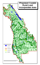
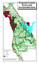
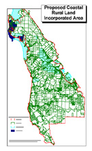
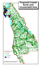
INCORPORATION OF "THE HAMLETS" aka RURAL LANDS AND DETACHMENT FROM THE MIDPENSULA REGIONAL OPEN SPACE DISTRICT
WHEREAS, the desires to initiate a proceeding for the reorganization boundaries specified herein;
NOW, THEREFORE, the does hereby resolve and order as follows:
1. Enabling Statute - This proposal is made, and it is requested that proceedings be taken, pursuant to the Cortese-Knox-Hertzberg Local Government Reorganization Act of 2000, commencing with Section 56000 of the California Government Code.
2. Reasons for Proposal - The reasons for the proposal are to (a) increase local control and accountability for decisions affecting the community, (b) secure self governance through a Town Council elected by local residents; (c) retain local tax revenues for use in the community to support school districts, municipal programs and services, (d) preserve, protect and sustain the quality of life and values prevailing within the proposed Town, (e) promote cost-effective services tailored to the needs of local residents and landowners and (f) provide coordinated "Fire Safe" resource management and planning services for vital community interests including watershed natural systems, parks and open space.
3. Description of Proposal - The proposal is a reorganization that includes the following changes of organization;
A. Incorporation of a municipality to be known as The Hamlets.
B. Detachment of territory from the Midpeninsula Regional Open Space District
4. Boundaries - The boundaries of the proposal are described in the map labeled Exhibit A attached hereto and by this reference incorporated herein.
5. Registered voters - The territory included in the proposal contains approximately 3,600 registered voters.
6. Spheres of Influence - The proposal is consistent with the spheres of influence of all affected local agencies except for the Midpeninsula Regional Open Space District and it is hereby requested that the District sphere be amended to permit this proposal.
7. Name This incorporated municipality shall be the Town of Rural Lands.
8. Effective Date The effective date of the incorporation shall be July 4, 2004 or as soon thereafter as possible
9. Legislative Body The Town shall be governed by a 7-member Town council elected by division.
10. Council Terms of Office The terms of office of Town Council members shall be four years. Of the first elected legislative body, the terms of the 3 members the largest popular vote shall be 4 years. Of the first elected legislative body, the terms of the 2 members with the least popular vote shall be 2 years.
11. First Town Council Meeting In addition to all other means authorized by law, the first meeting of the Town council may be called by notice given in a lawful manner by any three members of the Town Council.
12. Form of Organization The Town Council shall appoint a Town manager who shall fill the positions of Town Clerk and Town Treasurer by appointment.
13. Provisional Appropriations Limit LAFCO shall establish a provisional appropriations limit sufficient to accommodate reasonable and possible future increases in proceeds of taxes received by the Town.
14. Continuation of Existing General Taxes The Town shall be authorized to levy as general taxes of the Town those general taxes which are from time to time levied by the County including (1) a sales and use tax collected under contract with the State Board of Equalization and returned to the Town pursuant to applicable law, (2) a transient occupancy tax on gross receipts of hotels, motels, and similar facilities within the Town and returned by the operators of such facilities pursuant to local ordinance, (3) a business license tax to be collected by the Town pursuant to local ordinance, and (4) all other applicable general taxes presently imposed by the County to be collected by the same method of collection as used by the County.
15. Continuation of Charges, Fees, and Assessments The Town shall be authorized to continue to levy charges, fees and assessments of the Town that are from time to time levied by the County or any of the subject agencies of this incorporation.
16. Transfer of Assets
A. On the date of incorporation, or as soon thereafter as practicable, the County shall transfer to the Town a proportionate share of all assets, physical and personal, monies or funds, including cash on hand and monies due but uncollected, of the County and of County-governed districts for which services the Town will become responsible after incorporation, said share to be determined by LAFCO based upon its evaluation.
B. On the date of incorporation, or as soon thereafter as practicable, County-owned properties and other physical assets situated within the incorporation area and related to services the Town will become responsible after incorporation shall be transferred to and become the property of the Town without payment of compensation by the Town to the County, said assets to be determined by LAFCO based upon its evaluation.
C. On the date of incorporation, or as soon thereafter as practicable, all District-owned properties and other physical assets of the Midpeninsula Regional Open Space District situated within the reorganization area shall be transferred to and become the property of the Town without payment of compensation by the Town to the District.
17. Single Ballot Question The question of incorporation, all related boundary changes, and all terms and conditions shall be presented as one question on the ballot.
PASSED AND ADOPTED this day of .
President/Mayor, Board of Directors/City Council
AYES:
NOES:
ABSENT:
NOTICE OF INTENT TO CIRCULATE PETITION
(pursuant to Section 56700.4 of the Cortese Knox Hertzberg
Local Government Reorganization Act of 2000)
Notice is hereby given of the intention to circulate a petition proposing: The incorporation of the San Mateo County unincorporated Rural Lands. The reorganized incorporation area shall be known as: Rural Lands Inc.
The reasons for the proposal are: When in the Course of human events, it becomes necessary for one people to dissolve the political bands which have connected them with another, and to assume among the powers of the earth, the separate and equal station to which the Laws of Nature and of Nature's God entitle them, a decent respect to the opinions of mankind requires that they should declare the causes which impel them to the separation.
Sustainable San Mateo County Database: LAND USE DATA
| Allocation of Land Uses by County |
| County |
Urban% |
Rural% |
Greenbelt% |
Estimated
UDI1 |
| Alameda |
29.2 |
56.9 |
21.6 |
25 |
| Contra Costa |
30.2 |
46 |
23.8 |
16 |
| Marin |
14 |
35 |
51 |
14 |
| Napa |
4 |
75.8 |
20.2 |
16 |
| San Francisco |
79.4 |
1.3 |
19.3 |
92 |
| San Mateo2 |
26.2 |
39.1 |
34.7 |
22 |
| Santa Clara |
21.5 |
56.9 |
21.6 |
21 |
| Solano |
9.7 |
71.1 |
19.2 |
8 |
| Sonoma |
6.3 |
83.7 |
10 |
18 |
|
Source: Greenbelt Alliance: Greenbelt at Risk 2000
1. Urban Density Index (UDI): Total housing units/urban square miles/100. Source: US Census 2000
2. Total area of San Mateo County is 285,339 acres. |
We hold these truths to be self-evident, that all men are created equal, that they are endowed by their Creator with certain unalienable Rights, that among these are Life, Liberty and the pursuit of Happiness. (Battered Rural Communities, large pdf, be patient please) That to secure these rights, Governments are instituted among Men, deriving their just powers from the consent of the governed, That whenever any Form of Government becomes destructive of these ends, it is the Right of the People to alter or to abolish it, and to institute new Government, laying its foundation on such principles and organizing its powers in such form, as to them shall seem most likely to effect their Safety and Happiness. Prudence, indeed, will dictate that Governments long established should not be changed for light and transient causes; and accordingly all experience hath shewn, that mankind are more disposed to suffer, while evils are sufferable, than to right themselves by abolishing the forms to which they are accustomed. But when a long train of abuses and usurpations, pursuing invariably the same Object evinces a design to reduce them under absolute Despotism, it is their right, it is their duty, to throw off such Government, and to provide new Guards for their future security.-- Such has been the patient sufferance of these Rural Lands; and such is now the necessity which constrains them to alter their former Systems of Government. The history of the present County of San Mateo is a history of repeated injuries and usurpations, all having in direct object the establishment of an absolute Tyrannyover these Rural Lands. To prove this, let Facts be submitted to a candid world .
Submitted By: Half Moon Bay Coastside Foundation aka Save Our Bay on March 19, 2003
Address: 1589 Higgins Canyon Road, Half Moon Bay, Ca 94019
Telephone Number: 650-867-5779
Prior to circulating any petition for boundary change please complete this form and submit it to San Mateo Local Agency Formation Commission, 455 County Center, Redwood City, CA 94063. If you have any questions, please contact Martha Poyatos at (650) 363-4224.
POST YOUR COMMENTS AND QUESTIONS HERE...
``REGIME CHANGE" FOR SMC THE RURAL LANDS
April 10, 2003
To:
Honorable Rose Jacobs Gibson, President , SMC Board of Supervisors
Honorable Don Horsley, Sheriff , San Mateo County
Honorable Steve Wert, CDF Unit Chief, San Mateo & Santa Cruz County
Honorable John Sims, Chief CDF San Mateo County Fire
Honorable James Ashe, Chief Half Moon Bay Fire Protection District
Honorable Meg Delano, Chair, Pescadero Municipal Advisory Council
Martha Poyatos, LAFCo Executive Officer
From:
Oscar Braun, Executive Director, HMB Coastside CRMP & Fire Safe Councils
Subject:
Rural Lands Incorporation aka Regime Change
On March 19, 2003, the Half Moon Bay Coastside Fire Safe & CRMP Council formally filed: ``Notice is hereby given of the intention to circulate a petition proposing: The incorporation of the San Mateo County unincorporated Rural Lands. The reorganized incorporation area shall be known as: Rural Lands Inc." (See attached NOI). The act of incorporation is a legal and administrative change and does not itself produce an environmental effect. The incorporated Rural Lands will be guided and in full conformance with the certified San Mateo County General Plan and Local Coastal Program. The new reorganized community of the Rural Lands will in fact simply have a ``regime change" from an elected municipal ``advisory council" to an elected ``Rural Lands Governing Council.
The only community services currently allowed under the San Mateo County General Plan and Local Coastal ``apartheid" Program for the Rural Lands area residents and recreation tourist are substandard roads, fire and law enforcement protection. The San Mateo County Board of Supervisors codified the reduction of these vital public health and safety services by adopting the Committee for  Green Foothills and Sierra Clubs Coastside Protection Initiative of 1994. Section 1. Purpose of this Measure: Reduction of Government Expenditures. To reduce the cost to San Mateo County taxpayers of roads, law enforcement, fire protection, and other government services for scattered and remote development aka Rural Lands. The San Mateo County Fire Safe Committee has been notified by Sheriff Horsley, because of budget reductions exceeding twelve per cent, that the Sheriff Green Foothills and Sierra Clubs Coastside Protection Initiative of 1994. Section 1. Purpose of this Measure: Reduction of Government Expenditures. To reduce the cost to San Mateo County taxpayers of roads, law enforcement, fire protection, and other government services for scattered and remote development aka Rural Lands. The San Mateo County Fire Safe Committee has been notified by Sheriff Horsley, because of budget reductions exceeding twelve per cent, that the Sheriff  Department is shutting down the Men's Correctional Center and will not be able to fund any Fire Safe Crews. San Mateo County has created the worlds largest `` regional urban recreational theme park" (over 94,000 acres of parks & open space) while exhibiting a reckless disregard for the publics health and safety in addition to jeopardizing the entire San Francisco Peninsula wildland urban interface (WUI) vital watershed resources to a catastrophic disruption. (See attached) Department is shutting down the Men's Correctional Center and will not be able to fund any Fire Safe Crews. San Mateo County has created the worlds largest `` regional urban recreational theme park" (over 94,000 acres of parks & open space) while exhibiting a reckless disregard for the publics health and safety in addition to jeopardizing the entire San Francisco Peninsula wildland urban interface (WUI) vital watershed resources to a catastrophic disruption. (See attached)
Question: Total Parks & Open Space acres in San Mateo County? Answer: Shared Vision 2010
Question: How many houses in the Rural Lands & how many acres? Answer: SMC Housing Log
Question: How much Open Space Greenbelt in the Bay Area: Answer: Over 1 Million Acres!
Sustainable San Mateo County Database: LAND USE DATA
| Allocation of Land Uses by County |
| County |
Urban% |
Rural% |
Greenbelt% |
Estimated
UDI1 |
| Alameda |
29.2 |
56.9 |
21.6 |
25 |
| Contra Costa |
30.2 |
46 |
23.8 |
16 |
| Marin |
14 |
35 |
51 |
14 |
| Napa |
4 |
75.8 |
20.2 |
16 |
| San Francisco |
79.4 |
1.3 |
19.3 |
92 |
| San Mateo2 |
26.2 |
39.1 |
34.7 |
22 |
| Santa Clara |
21.5 |
56.9 |
21.6 |
21 |
| Solano |
9.7 |
71.1 |
19.2 |
8 |
| Sonoma |
6.3 |
83.7 |
10 |
18 |
|
Source: Greenbelt Alliance: Greenbelt at Risk 2000
1. Urban Density Index (UDI): Total housing units/urban square miles/100. Source: US Census 2000
2. Total area of San Mateo County is 285,339 acres. |
The Rural Lands proposed fiscal municipal model assumes continuation of the same revenue streams currently being received by the County to pay for their LCP mandated substandard levels of protective service imposed upon providers CDF, HMBFD and SMC Sheriff Department. The Rural Lands proposed revenue model imposes a new municipal Rural Lands CRMP user fee scheme for all ``non  tax paying property owners". The Rural Lands CRMP user fees, some authorized under PRC 4290 & PRC 4291 for example, will generate over $20 million dollars more per year for roads, fire and law enforcement services. The incorporated Rural Lands will contract with CDF and the SMC Sheriff's Department to provide prudent and mandated fire and police services including the SMC Fire Safe Crews. The incorporated Rural Lands will provide it's residents and all Californians the highest level of health and safety services. Why, because California taxpayers have paid for it and demand nothing less when it comes to their homeland security. The residents of the Rural Lands are unwilling to continue to suffer the tyrannical apartheid policies imposed upon them by this dysfunctional urban Board of Supervisors that serves at the pleasure of the Committee for Green Foothills and Sierra Club. God Bless America! tax paying property owners". The Rural Lands CRMP user fees, some authorized under PRC 4290 & PRC 4291 for example, will generate over $20 million dollars more per year for roads, fire and law enforcement services. The incorporated Rural Lands will contract with CDF and the SMC Sheriff's Department to provide prudent and mandated fire and police services including the SMC Fire Safe Crews. The incorporated Rural Lands will provide it's residents and all Californians the highest level of health and safety services. Why, because California taxpayers have paid for it and demand nothing less when it comes to their homeland security. The residents of the Rural Lands are unwilling to continue to suffer the tyrannical apartheid policies imposed upon them by this dysfunctional urban Board of Supervisors that serves at the pleasure of the Committee for Green Foothills and Sierra Club. God Bless America!
POST YOUR COMMENTS AND QUESTIONS HERE...
|
Register in the Rural Lands Community Guest Book
Please enter your name and password then click on ``Instant Member".
The next page that opens will have the Rural Lands registration form fields. The purpose of the registry is to get the mailing address and email of property owners and residents in the proposed Rural Lands incorporated area. ALL INFORMATION IS CONSIDERED CONFIDENTIAL AND WILL NOT BE SHARED OR SOLD. Be sure to note your name and password so that you'll be able to either edit your registry information or remove yourself from the registry guest book.
Thank you. |
 |
|
|
|
|
|
Log In and Edit Guest Book Listing!
Please enter your user name and password then click on ``Member Page". exThis will allow you to edit your entry or delete yourself from our confidential database.
|
|
|
|
EXECUTIVE SUMMARY: RURAL LANDS INC.
INITIAL FISCAL ANALYSIS (IFA) of the proposed incorporation of San Mateo County ``RURAL LANDS" area.
The Half Moon Bay Coastside Foundation is a non-profit 501©3 Coordinated Resource Management and Planning Council (CRMP) dba as the California Watershed Posse (CWP).The CWP CRMP services comines expertise in land economics consulting with experience in the full spectrum of services related to real estate development, the financing of government services and public infrastructure, land use and conservation planning, and government organization. The CWP has drafted an Initial Fiscal Analysis (IFA) of the proposed incorporation of the Rural Lands area of San Mateo County. The IFA provides an initial evaluation of city hood feasibility and potential impacts on the County. The IFA is intended to serve as a ``fatal flaw" analysis of incorporation feasibility, and to identify issues requiring further research as part of a formal Comprehensive Fiscal Analysis (CFA) required by law.
The proposal incorporates approximately a 100,000 acres unincorporated area of the San Mateo County Rural Coastal Zone, referred to as Rural Lands. Approximately 94,810 acres (95%) of the total Rural Lands Inc. area is government and land trust owned. The unincorporated Rural Lands area in the San Mateo County coastal zone are: Shamrock Ranch/Rancho Corral de Tierra in the north, Higgins/Purisima/Tunitas east of urban mid-coast area, South Skyline Area, San Gregorio, La Honda, Pomponio, Pescadero,, Butano, Bean Hollow, Gazos, and Ano Nuevo on the south coast . Approximately 6,453 people reside within the IFA study area.
RURAL LANDS DEMOGRAPHICS: Shared Vision 2010
Question: Total Parks & Open Space acres in San Mateo County? Answer: Shared Vision 2010
Question: How many houses in the Rural Lands & how many acres? Answer: SMC Housing Log
Question: How much Open Space Greenbelt in the Bay Area: Answer: Over 1 Million Acres!
Total Rural Lands Area: 99,621 Acres (100%)
Total Privately Held Taxpaying: 4,811 Acres (4.82%)
Total Government & Land Trust : 94,810 Acres (95.18%)
Seton's Rural Lands Service Area (source HCIA Sachs,Claritas)
County Zip Code Zone Pop 2001 Pop 2006
San Mateo 94020 La Honda 1,897 1,899
San Mateo 94021 Loma Mar 173 175
San Mateo 94038 Pescadero 2,186 2,208
San Mateo 94074 San Gregorio 326 334
San Mateo 94019 Mid=Coast Rural 1,868 1,871
______________________________________________________________
6,450 6,487
By Age Group Pop 2001 Pop 2006
0-14 21% 20%
15-24 10% 12%
25-44 32% 27%
45-64 26% 29%
65-79 8% 9%
80 plus 3% 3%
By Race/Ethnicity Pop 2001 Pop 2006
White 74% 70%
Black 1% 1%
Asian 5% 7%
Hispanic 19% 22%
The Summary Conclusions of the IFA are the following:
 Rural Lands can be financially feasible as a city based on the Municipal Budget Model which shows a budget surplus starting in the first year of operation. This conclusion does not however consider potential fiscal mitigation payments to the County. Rural Lands can be financially feasible as a city based on the Municipal Budget Model which shows a budget surplus starting in the first year of operation. This conclusion does not however consider potential fiscal mitigation payments to the County.
- The municipal General Fund budget (annual revenues minus annual expenditures) is projected to exceed $100,000 by its second full year of operation, which is assumed to be 200304. The financial condition of the city improves considerably with each additional year of operation. Fund balances and contingencies could cover any nominal future year deficits, if they occur.
Revenues transferred to Rural Lands from the County will not exceed expenditures transferred. A revenue neutrality mitigation payment to the County is required under State law; specific terms and amounts are to be negotiated between the proponents and the County.
 Revenue sources for the proposed Rural Lands incorporated area will include: property tax (a proportion of the share that currently goes to the County), one percent of taxable sales generated within the area, property transfer tax, franchise fees, transient occupancy tax (nine percent of hotel revenues), compensatory Rural Lands CRMP and mitigation fees, user fees, fines and penalties, State Motor Vehicle License Fees, as well as fee for service revenues. The IFA assumes no new taxes will be required nor imposed. Revenue sources for the proposed Rural Lands incorporated area will include: property tax (a proportion of the share that currently goes to the County), one percent of taxable sales generated within the area, property transfer tax, franchise fees, transient occupancy tax (nine percent of hotel revenues), compensatory Rural Lands CRMP and mitigation fees, user fees, fines and penalties, State Motor Vehicle License Fees, as well as fee for service revenues. The IFA assumes no new taxes will be required nor imposed.
Municipal service levels will at least equal existing levels. In some instances, however, service levels may improve qualitatively despite little or no difference in expenditure; for example, with planning administration located online, residents will have more convenient access to these services 24/7 as well as a greater degree of local control. In other instances, actual expenditures are assumed to be higher.
 The Rural Lands will be incorporated as a General Law town with a "Council/Manager" form of government, a five-person Council elected "by district" and a Council-appointed private sector non-profit community based Rural Lands CRMP Council responsible for day-to-day operations. The Rural Lands will be incorporated as a General Law town with a "Council/Manager" form of government, a five-person Council elected "by district" and a Council-appointed private sector non-profit community based Rural Lands CRMP Council responsible for day-to-day operations.
Access to all municipal Rural Lands government services will be online 24/7. Wireless Broadband service will be available to all the incorporated Rural Lands prior to the end of 2005 by Coastside Internet Services.
The Rural Lands will contract with the County Sheriff's Department for both law enforcement, traffic control and Fire Safe Crews.
 The Rural Lands CRMP Council will provide engineering services, manage capital improvement and maintenance efforts, manage municipal road and street lighting maintenance, oversee road maintenance and coordinated resource management and science based planning for all Rural Lands watershed natural eco-systems. The Rural Lands CRMP Council will provide engineering services, manage capital improvement and maintenance efforts, manage municipal road and street lighting maintenance, oversee road maintenance and coordinated resource management and science based planning for all Rural Lands watershed natural eco-systems.
The Rural Lands CRMP Council will be responsible for General Plan and Local Coastal Plan preparation, code enforcement, building inspection, building permits, and development services. All building permitting processes will be streamlined and accessible online 24/7. Most CDP building applications will be processed and approved within 30 days at a cost approximately 1/5 currently being charged by the County.
Animal Control services will be provided under contract with the County.
Fire protection services will be provided by CDF, La Honda Fire Brigade Inc. and the Half Moon Bay Fire Protection District under contract. All pre-fire vegetative fuel management services (PRC 4290 & PRC 4291) will be outsourced to private sector contactors on an open bid basis.
POST YOUR COMMENTS AND QUESTIONS HERE...
PROPOSED RURAL LANDS AREA PLAN ``Summary"
The Rural Lands Area Plan (RLAP) is intending to utilize the goals and policies of the San Mateo County (SMC) General Plan and Local Coastal Plan while providing more detailed guidance for future growth and development within the Rural Lands area of the County. The RLAP is adopting an ecosystem management implementation technique and strategy for conservation plan and utilizing creative solutions for conservation planning recommended by Economic & Planning Systems of Berkeley, California.
The following specific topics are addressed in the Rural Lands Area Plan in ``Summary" only; The complete draft of the entire Rural Lands General Plan will be published for public comment on the www.cwposse.org site prior to June 2003.
- Land Use
- Circulation and Transportation
- Open Space
- Public Utilities, Facilities and Services
- Public Safety
- Community Design
- Parks and Recreation
- Economic Development
Why the ``Help RID US" incorporation movement?
Since 1980, the entire Rural Lands communities area have suffered terribly by the unstable, incompetent and corrupt actions of SMC elected officials and planning staff. ``"The official SMC Housing Log 1980-2001 reveal that a total of only ``69" residential occupancy permits have been issued by the County of San Mateo. Why? Because of the Sierra Club and the Committee for Green Foothills undue influenced lobbying on local and state government has STOPPED all community development in the Rural Lands of San Mateo County. The SMC Local Coastal Plan's (LCP) policies of 0% Rural Lands Development are destroying the Rural Lands sustainability
by design. In short, the Urban majority of San Mateo County has imposed their ``apartheid" land use separation policies upon the residents of the Rural Lands communities. Why? For the purpose of annexation and transferring the entire San Mateo County Coastal Zone Rural Lands area to the Golden Gate National Recreation Area. (GGNRA) The Rural Lands residents of San Mateo County demand Environmental Justice for their families and will assume ``local control" of the coordinated resource management and planning of their Rural Lands communities starting in calendar year 2004. The San Mateo County Rural Lands farming communitites have lost over 42,000 acres of productive ranch and farm agricultural lands and irrigation water rights to the Mid-Peninsula Regional Open Space District (30,000 acres) and their private sector partner Peninsula Open Space Trust (12,000 acres) since 1973. The incorporation of the Township of the Rural Lands Hamlets will return those 42,000 acres acquired by the open space districts to the Township of the Rural Lands for productive agricultural purposes and conpetent local watershed stewardship.
Lots created in the Rural Lands during this period (1980-2002) were non existent. There was a substantial decrease (over 300) in buildable lots because of the thousands of acres purchased by open space trusts. Peninsula Open Space Trust (POST) acquired thousands of acres of prime agricultural lands while eliminating all the housing density credits from the rural communities and all property tax revenues. Almost all Rural Lands established parcels are served by on-site private wells and on-site septic systems. The majority of the road access being provided by state highways and private roads.
The total number of undeveloped parcels within the Rural Lands Plan area is approximately 1,200 lots. An undeveloped lot is one that has not made any improvements, including the addition of a well, etc. This includes lots in all land use designations from Agricultural and Open space areas, Residential areas, Institutional areas, and Commercial/industrial areas. Several modifications to residential land use designations have been proposed to more appropriately reflect actual build-out conditions in all areas of the Rural Lands subdivisions. The proposed area plan establishes an ``urban reserve" limit to clearly define the areas to be served by urban services, including community sewer and water systems. Within this urban reserve area are proposed two new land use designations.
Two (2) New Designations for the Rural Lands are being proposed.
The two new land use designations have been included to create an environment where residential, commercial and other similar and compatible uses may coexist with one another in an effort to facilitate economic development, create diverse housing and commercial opportunities, and improve the quality of life within the community by establishing a vibrant downtown area.
- The Central Core Mixed Use designation (CCMU) applies to core areas of Rural Lands communities. The CCMU is intended to bring both visitors and local residents together in a traditional downtown area, which would be characterized by common architectural elements, bike and pedestrian paths, common areas, and views of the rural watershed. The CCMU land use designation promotes a variety of uses. It will allow the ability to work, reside, conduct business, be entertained, recreate, shop, eat, and participate in civic and cultural activities in one integrated and planned location.
- By comparison, the Rural Lands Mixed Use (RLMU) designation applies to non central core Rural Land areas, consisting primarily of groups of parcels located along major arterials (Route 1, 84, 35, 92) and collectors in the planning area. The Rural Lands Mixed Use designation is intended to facilitate the combination of a variety of land uses, including residential, agricultural and commercial, within the same area and even within the same structure.
New `Area Plan' Outlines Rural Lands Facilities & Services
In this portion of the proposed Rural Lands area plan, we'll review the balance of the topics to provide more detailed guidance for future growth and development within the Rural Lands plan area.
Public Facilities, Utilities and Services Proposals
In order to achieve objectives regarding public facilities including adequate infrastructure for both existing development and anticipated growth, the Rural Lands Area Plan:
- Proposes to consolidate a full range of government services located online providing access 24/7.
- Proposes to consider acquisition and consolidation of existing water services in the Rural Lands while studying long range alternatives including surface water sources.
- Proposes to develop a program to expand the Rural Lands wastewater collection, treatment and disposal system to serve existing needs and for future growth.
- Encourage existing neighborhoods to develop and maintain common or private recreation or park areas.
Public safety, services
In order to provide adequate safety services and facilities for area residents, proposals are included for a study to assure not more than 10 minute response time in Rural Lands urban reserve areas and 15 minutes maximum response time to rural residential areas outside the urban reserve. These proposals consider evacuation planning, development of heliports for medical and fire suppression response and consideration of formation of a medical district to ensure 24-hour emergency service.
Circulation, Transportation
In order to provide adequate and safe circulation for both existing development and anticipated growth, proposals include road extensions to improve circulation and safety concerns within the Planning Area and surrounding area:
- Improvements relating to general population safety.
- Improvements relating to specific safety concerns, such as flooding of Pescadero Road at Butano Creek and clean potable drinking water for Rural Lands schools.
- Improvements related to neighborhood fire safety concerns
Fire Safe Council and communities developing pre-fire management plans.
- Improvements relating to general congestion reduction, such as reducing congestion along all State Highways leading into the Rural Lands.
- Improvements for safety concerns include providing a minimum of two points of ingress and egress for the visitor service areas and also for neighborhoods.
Economic Development
- For businesses, big, small or home-based, looking to locate or relocate within California, the San Mateo County Rural Lands is a great place to consider.
- Through this Area Plan and support of the Half Moon Bay Coastside CRMP & Fire Safe Council, many opportunities may be made available to business by the addition of a new area development in the Rural Lands CCMU and RLMU designated areas
POST YOUR COMMENTS AND QUESTIONS HERE...
``SHOW ME THE MONEY"
says former Half Moon Bay Mayor Naomi Patridge.
I ran into former Half Moon Bay Mayor Naomi Patridge the other day. I told Naomi I was very optimistic about the findings evolving from the Comprehensive Fiscal Analysis (CFA) for the Rural Lands incorporation. ``Oscar, You'll have to show me the money!" Well Naomi, that's not only a fair request
it's required pursuant to the Cortese Knowx Hertzberg Local Government Reorganization Act of 2000 administered by the Local Area Formation Commission aka LAFCo.
The Legislature has repeatedly DENIED LAFCo's direct role in regulating land use and property development. LAFCo's are charged with the broad policy mandate to preserve open space, discourage sprawl, and ensure ``orderly growth development". To do this, however, they have only the statutorily provided authority to review and approve incorporations and annexations, spheres of influence, and extensions of service beyond existing boundaries. The incorporation of the Rural Lands is for the sole purpose of empowering the resident rural minority self determination while assuming local, state, and federal regulatory mandated coordinated resource management and planning (CRMP) responsibilities within the boundaries of that area of San Mateo County known as the Rural Lands or wildlands.
The Rural Lands proposed fiscal municipal model assumes continuation of the same revenue streams currently being received by the County to pay for their LCP mandated substandard levels of protective service imposed upon providers CDF, HMBFD and SMC Sheriff Department. The Rural Lands proposed revenue model imposes a new municipal Rural Lands CRMP services user fee scheme for all ``non tax paying property owners". The list below identifies the property owner and the dollar amount anticipated receiving from CRMP, user and mitigation fees.
RURAL LANDS INC ANNUAL MUNCIPAL REVENUE STREAMS
Total Rural Lands Area: 99,621 Acres (100%)
Total Privately Held Taxpaying: 4,811 Acres (4.82%)
Total Government & Land Trust : 94,810 Acres (95.18%)
- California State Parks 15,811 Acres
CRMP, user and mitigation $100 per acre $1,581,100
- San Mateo County Parks 15,369 Acres
CMRP, user and mitigation $100 per acre $1,536,900
- San Francisco Watershed 23,000 Acres
CMRP, user and mitigation $100 per acre $2,300,000
- Mid-Peninsula Open Space 27,030 Acres
CRMP, user and mitigation $100 per acre $2,703,000
- Peninsula Open Space Trust 9,600 Acres
CRMP, user and mitigation $100 per acre $960,000
- Golden Gate Nat'l Rec. Area 4,000 Acres
CRMP, user and mitigation $100 per acre $40,000
____________________________________________________
Total CRMP, User & Fire Safe mitigation fees $9,962,100.00
NOTE: Property ,sales taxes and other revenues not yet available.
Question: How much Open Space Greenbelt in the Bay Area:
Answer: Over 1 Million Acres!
WUI & RURAL LANDS FIRE SAFE COUNCIL
9/11 ALERT S.F. Peninsula Watershed Security Plan
1) The California Watershed Posse (CWP) has established four private sector rural lands 501C3 non-profit community based Councils for the purpose of protecting California's future. Our mission is to develop & implement State (CEQA) and Federal (NEPA) adopted watershed coordinated resource management plans (CRMP) in rural and wildland areas of California.
- Rural Lands CRMP Council
- Water Quality Protection Program (WQPP)
- WUI & Rural Fire Safe Council
- Rural Lands Invasive Species Council.
2) The California Watershed Posse in the fall of 2001 initiated a collaborative effort with the leading international innovator of natural systems ambient light sentinel technology Ambient Control System. The out come of that collaborative effort was the development of a strategic watershed sentinel AmbientAlert CRMP for the San Francisco Peninsula Watershed located in San Mateo County. The 9/11 San Francisco Watershed Security Plan proposes 21st century solutions to the multiple challenges in protecting our watershed vital natural resources from invasive species (wild pigs), terrorist attack, catastrophic wildfires and non-point source pollutions. The California Watershed Posse is seeking State and Federal partnership and funding for the deployment of the Ambient Control FireALERT, FluidALERT, IntruderALERT and InvasiveALERT sentinel systems.
3) It is no secret that the San Mateo County (SMC) Rural Coastal Zone (RCZ )valuable resources. The SMC RCZ wildland watershed is a State Responsibility Area (SRA) which includes the coastal unincorporated Rural Lands communities with approximately 6,300 residents (see RCZ map) and is also haven for a variety of habitats which supports the highest concentration of rare, threatened, and endangered species in the Bay Area. The San Andreas, the Lower & Upper Crystal Springs and the Pilarcitos Reservoirs, nestled between the Santa Cruz Mountains and the 280 Freeway, are said to contain some of the purest drinking water in the United States. What is not well known is that the spectacular and beautiful surrounding rural landscape harbors a serious threat to this prized commodity. Long years without a major wildfire have allowed a serious buildup of biomass that could, according to the California State Auditor's SFPUC February 2000 Report, fuel a catastrophic firestorm in a region that lacks a rapid fire response capability enjoyed by most inner-city fire departments. A major wildfire driven by blazing hot Diablo winds could explode over and beyond the eastern facing slopes above the reservoirs only to be stopped at our coastal waters edge after stripping the groundcover of its ability to hold back soil and long hidden pollutants when the heavy rains come. The last major wildfire in this SMC RCZ watershed occurred in 1946 which resulted in reduced capacity of the reservoirs because of the vast sedimentation that followed the fires. The GGNRA Fire Management Plan records describe the damaging 1946 wildland fire as having lasted for six weeks, completely burning down the small coastal community of Montara. In year 2001, the Half Moon Bay Fire Protection District alerted SMC RCZ coastal communities that all the conditions that caused the disastrous 1946 wildfires now currently exist in our coastal watersheds. High temperatures, warms Santa Ana winds, steep hills, excessive wildland vegetation, drought affected plants, narrow roads, slow wildland fire detection and densely populated wildland /urban interface area (WUI) neighborhoods all contribute to firestorms. The result will be streams, the ocean, bays and reservoirs degraded with nonpoint source pollution that could, according to the Bay Area Water Users Association, potentially cause the 2.4 million Bay Areas regional water users, the loss of drinking water for a period of 4 to 8 weeks.
4) Fuel Management (the removal of groundcover and old & diseased trees) is the State of California fire prevention policy that is designed to deal with the problem of excessive biomass in the wildland. However, the laws of physics always seem to prevail; for every action, there is a reaction. Prescribed burns and/or the mechanical removal of the flora in this delicate ecosystem would unquestionably reduce the threat of a major wildfire, although it is expensive, must be maintained in perpetuity and it does not prevent them. So, regardless of prescription, an unplanned wildfire stripping the groundcover, or planned fuel management doing the work, the problem of soil erosion will be ever present above the reservoirs. Under any prescription, the SMC RCZ communities are at the highest risk from a catastrophic firestorm.
5) Early detection of wildfires is certainly a more proactive strategy than simply waiting for an inevitable event to occur. The problem is the current detection method in wildland areas is wholly dependent on visual observation. This system works well if wildfires ignite in areas that are clearly visible to the public and during the daylight hours when the majority of the community is awake, but nature and arsons do not typically start fires when and where it is most convenient to the majority of the population. Anecdotal evidence of previous wildfire events in this area (August 10,1999) indicates that they have sometimes burned for days before being spotted. If one of those events had actually occurred during conditions that were optimum for a wildfire, this current discussion regarding potential nonpoint source pollution would be solely academic.
6) One suggestion that would help the SWRCB protect the SMC RCZ watershed is to think outside of the box. This is the 21st Century, why not utilize a proven technological solution? The Bay Area is, after all, the science and technological center of the universe. First, consider that the City of San Francisco Fire Department's average response to a structural fire is two minutes. Second, because of this rapid response, very few structures and almost no lives are lost to fire. The Fire Department has been assisted in this most commendable accomplishment by innovative city building codes that require commercial structures to have state-of-the-art fire detection-alarm systems. These codes are designed to promote rapid response that will typically result in quick suppression, while the fire is small; rather than having to face a fully engaged fire that could potentially cause total structure loss and place the firefighters and inhabitants in great danger.
7) To protect the SMC RCZ watershed from nonpoint source pollution, the California Watershed Posse (CWP) proposes the deployment of a 9/11 ALERT (Ambient Light Early Response Technologies) sentinel system that would provide the responsible fire agency(s) with the same tools utilized by the San Francisco Fire Department in their successful fire suppression model. The challenge is to identify a system that is as reliable as their AC powered detection-alarm system. Unfortunately, there is no infrastructure to support AC power in the wildland and to suggest it, as an option would not be economically or politically feasible. Remote battery operated systems are certainly an option, but they fail the test because of expensive maintenance issues and a long history of unreliability.
8) The FireALERTtm system uses 21 st Century technology to provide a reliable, maintenance free, early warning wildfire detection-wireless alarm system designed to protect the wildland from wildfires. Each FireALERTtm system is programmed with a unique geographic address and reports system integrity to a central control center each morning. It also reports if it is vandalized or tilted. It additionally has a lost hiker/medical emergency call box feature.Its primary component is a patented, stand-alone energy platform that does not require AC power or batteries to operate. The platform has been developed and refined over a twelve-year period and has an expected life of over 20-years. It currently powers a computerized water management system that is used in over 800 government entities in North America and over 20,000 units have been sold around the world. Its four primary elements are energy collection, energy storage, digital processing and telemetry. The energy collection is achieved with a customized photovoltaic module that is designed to perform efficiently in a harsh desert sun, heavy shade, and under freezing winter storm conditions. The energy is managed and stored in super capacitors for utilization 24 hours per day, 7 days per week. The microprocessor analyzes data and transports it by wireless transmission to a field handheld receiver, or to a repeater, and/or up-linked to a satellite and down-linked to any location around the world.
9) The other component is a proprietary Spectral Resonance Imaging (SRI) sensor used to detect the unique signature of fire. The SRI Technology completes a 360o sweep once every minute looking for a fire signature. It has a view up of 45o, and a 45o view down, a range of ¼ mile, and moves at 6o increments on the horizontal plane. As it sweeps it builds a history of typical background noise and a threshold is created. When the SRI sensor detects a fire signature of 48" x 48" or greater at ¼ mile, it returns to the targeted coordinate twice to determine if the fire signature is growing. If the fire signature continues to grow after the third look, a wireless alarm is dispatched from up to twelve-miles to a central control center and/or handheld receiver. If the transmission is greater than twelve-miles, or disturbed by topography, the alarm is sent to a repeater station and/or up linked to a satellite and down linked to a central control station anywhere in the world. Within three minutes of fire ignition an alarm providing exact location, direction, size, available biomass fuel, topography, access to the site, etc. is being viewed in real time as a virtual image by a fire agency's rapid response team coordinator. Information derived from the FireALERT tm system allows the coordinator to allocate, with a few simple keystrokes, the number of personnel and fire suppression resources (who will already be on-standby) that will be required to suppress a small fire before it becomes a catastrophic wildfire.
10) Now that the same reliable platform that supports the FireALERTtm also supports the FluidALERTtm the IntruderALERTtm, and soon the InvasiveALERT systems. The FluidALERTtm was originally designed for a mountain top stream application and the IntruderALERTtm for a border patrol application. Unfortunately, their applications were redirected after the events of September the 11th, when civic infrastructure was compromised in a way that was previously never imagined in the long history of the United States. An arson/chemical/biological terrorist attack on the Bay Area's Hetch Hetchy regional water supply is no longer just a plot for some fictional Hollywood movie; it is a terrorist's war strategy.
11) The FluidALERTtm is designed to measure water volume, flow and quality. When the state water quality agency determines under the 303(d) process that a stream is impaired by specific pollutants, it must establish a ``total maximum daily load" (TMDL) for those specific pollutants that will allow the stream to ``recover" and once again meet water quality standards for its designated users NPDES permit. The FlluidALERT can be programmed to provide the SWRCB 24/7 real time monitoring of the TMDL's of impaired SMC RCZ water bodies. Units spaced around SMC RCZ streams, bays and perimeter of the reservoirs daily report integrity and statistical data in batches to a central control station over a wireless network. If an event occurs that alters the water chemistry from what is the accepted norm, a wireless alarm is immediately transmitted to a central control station identifying exact location of detection. The FluidALERTtm will also immediately report a vandalized or tilted condition to the central control station via the wireless communication network
12) The IntruderALERTtm is designed to detect vehicle, human and the InvasiveALERT tracks massively distructive and deceased ``wild pig" intrusion. Each day, units spaced around the perimeter of the reservoirs report system integrity to the central control station via a wireless communication network. If an unauthorized intrusion event occurs, a wireless alarm is immediately sent to the central control station identifying location of detection. The IntruderALERTtm and InvasiveALERT will also immediately report a vandalized or tilted condition to the central control station via the wireless communication network.
13) In Conclusion, the Half Moon Bay Coastside Foundation dba California Watershed Posse proposes to protect the SMC RCZ watershed from nonpoint source pollution by supplying and deploying a 500 unit FireALERTtm wildfire detection-wireless alarm system, a 120 unit FluidALERTtm system , a 120 unit IntruderALERTtm and 500 unit (wild pig) InvasiveALERT system. The goal of our SMC coastal community-based foundation's coordinated resource management plan (CRMP) is to strategically address existing water quality concerns and to prevent the kinds of expensive catastrophic events that have occurred elsewhere in the country. Our SMC RCZ communities have increasingly realized that nature is not simple to be  used or passively appreciated, but that we are all part of the natural world and that our earth's natural resources have inherent value. Through sound decision making, conservation practices, and wise land usage we can help sustain and renew these natural resources for future generations. The SMC RCZ communities will do their part to protect the water quality and remaining rural wildland habitat areas. It is a shared opportunity to be responsible stewards of vital but fragile watershed resources. The economic and environmental benefits of the AmbientALERT sentinel systems are the protection, enhancement, and restoration of San Mateo County coastal watersheds, riparian stream zones, and wetlands. A rapid 9/11ALERT deployment will reduce the need for costly new water treatment plants, provide high quality drinking water at reduced cost, reduce the cost of flood damage, and improve water quality for aquatic ecosystems and human recreation. The AmbientALERT sentinel systems, FireAlert, FluidAlert, IntruderAlert and InvasiveALERT will provide the SMC RCZ communities with a 21 st Century technological homeland security solution. We must never forget the terrorist lesson of September 11, 2001. used or passively appreciated, but that we are all part of the natural world and that our earth's natural resources have inherent value. Through sound decision making, conservation practices, and wise land usage we can help sustain and renew these natural resources for future generations. The SMC RCZ communities will do their part to protect the water quality and remaining rural wildland habitat areas. It is a shared opportunity to be responsible stewards of vital but fragile watershed resources. The economic and environmental benefits of the AmbientALERT sentinel systems are the protection, enhancement, and restoration of San Mateo County coastal watersheds, riparian stream zones, and wetlands. A rapid 9/11ALERT deployment will reduce the need for costly new water treatment plants, provide high quality drinking water at reduced cost, reduce the cost of flood damage, and improve water quality for aquatic ecosystems and human recreation. The AmbientALERT sentinel systems, FireAlert, FluidAlert, IntruderAlert and InvasiveALERT will provide the SMC RCZ communities with a 21 st Century technological homeland security solution. We must never forget the terrorist lesson of September 11, 2001.
Rural Lands Comprehensive Fiscal Analysis Resource Documents
- California Watershed Posse (CWP) 21st Century Mission Statement
- Sierra Club Regional Group 1971 Coastal Rural Lands Vision
- Loren McQueen v. Mid-Peninsula Regional Open Space District
- 2003 San Mateo County Agricultural Summit
- Natures Landlord, Worlds Most Powerful Enviro-Group Exposed
- Nature Conservancy, Washington Posts Insightful Green Series
- Undue Influence, Ron Arnold
- Rural Battered Communities Testimony
- 5th Column Versus Us
- The Real Monsters of the Coastal Rural Lands
- The Sierra Club $300 Billion Dollar Tunnels Boondoggle
- Think Tunnels: Sooner, Safer, Cheaper
.Never!!!
- Devils Slide Tunnels Notice of Violation : Endangered Species Act
- Save Devils Slide Highway Funding Letter, Sec. Norman Mineta
- Devils Slide Declared No Substantial Issues by CCC
- CCC, CGF & Sierra Club Tunnels Mitigation Scheme Kills Fed Funding
- "Pay to Play" Gov. Davis & Unconstitutional CCC
- Sierra Club & Gov. Davis Hetch Hetchy Hidden Agenda
- No RICO Government For Us
- Parks & Open Space Environmental Data (POSTed)
- EPA, U.S. Attorney, IRS, RICO Referral October 2001
- CGF & BOS Retaliate and Order Abatement of Rural Land Families
- SOB Supports Raymond Levine Rural Lands Home Project
- Final Notice of Violation BOS Jerry Hill re: POST Landfill et all.
- War Declared on Open Space off-roaders
- Golden Gate National Recreation Area Reactive Maintenance Report
- Cutting Green Tape: Toxic Pollutants, Environmental Regulations & Law
- Wise Use Versus "Smart Growth" Essay
- San Mateo Agricultural Summit Keynote Presentation, Steve Oku
- 2003 San Mateo Agricultural Summit Agenda & Reports
- Why the Peninsula Agriculture lands keeps disappearing!
- Sign the No MROSD Coastal Annexation Petition
- Ron Sturgeon Comments re: MROSD EIR
- La Honda-Pescadero School District Comments re: MROSD Draft EIR
- San Mateo County Association of Realtors Comments MROSD Draft EIR
- La Honda Fire Brigade Inc. Comments regarding MROSD Draft EIR
- Mary Clayton, Co-chair Coastal Family Alliance re: MROSD annexation
- Carol Simon, Comments re: MROSD Draft EIR
- Petrea Hamor, Comments re: MROSD Draft EIR
- No MROSD Annexation Op/Ed Letter by Deborah Ettinger
- Anti-MROSD Annexation Op/Ed Letter by Susan True
- Andy Braun, Comments & Questions re: MROSD Draft EIR
- Oscar Braun, July 2002, Comments & Question MROSD Draft EIR
- John Donovan, Consensus re: Butano Creek Enhancement Project
- CWP Fire Safe Council Offers Sponsorship for Butano Creek Project
- CWP Fire Safe & CRMP Council Follow-up letter to PMAC
- Just Ask Your Neighbor About the San Mateo County RCD.
- CWP Water Quality Testing Studies
- CWP Proposed Confined Animal Ordinance
- CWP Opposes Access into SFPUC Watershed Sensitive Habitat Areas
- Fire Prevention Grant Proposal: Ambient FireAlert Sentinel System
- Fire Prevention Grant Proposal: S.F. Peninsula Regional EIR Template
- LAFCo Regulations
- San Mateo County 2002 Comprehensive Annual Financial Report
- California Coastal Act
- San Mateo County General Plan
- San Mateo County Local Coastal Plan
- San Mateo County Environmental Services, Documents, Maps & Figures
- 1994 San Francisco Public Opinion on Watershed Management Issues
- California Watershed Posse Water Quality Protection Program
- California Rangeland Water Quality Management Plan
- Council on Environmental Quality
- The Wildland Project
- Healthy Forest Initiative
- CWP San Francisco Peninsula Watershed Security Plan 2001
- California CRMP Council A Local Approach
- California Watershed Posse (CWP) CRMP Council Services
- California Watershed Posse Fire Safe Council
- California Fire Plan
- CDF Monitoring Study Group Monitoring Program
- Environmental Justice Presidential Order
- National Invasive Species Management Plan
- Endangered Species Act
- Clean Water Act
- Ecosystems Management , Techniques and Implementation
- Creative Solutions in Regional Conservation Planning by E & P System
- Ambient Control Sentinel Systems
- Study of Wildland Fire Suppression Cost
- Meeting the challenges of Homeland Security in the SF Bay Area
POST YOUR COMMENTS AND QUESTIONS HERE...
|

